“The world has enough beautiful mountains and meadows, spectacular skies and serene lakes. It has enough lush forests, flowered fields. It has plenty of stars and the promise of a new sunrise and sunset every day. What the world needs more of is people to appreciate and enjoy it,,
Rajouri and Poonch region has a treasure trove of sites of historical and pilgrim importance which need to be highlighted and projected on the state’s tourism map to open a new era of Heritage Tourism in Jammu & Kashmir and change the economic landscape of the region.
The oval-shaped Sat Sars (seven lakes), located on Rajouri Poonch-Shopian border of Pir Panchal range, seventy km from district hqrs., are located at a height of 3500 meters. These include Nandan Sar, Gum Sar (hidden lake), Kal dachni (dark water lake), Sukh Sar (dried lake) Neel Sar (blue lake), Katori Sar (bowel lake) and katanan or Sarota Sar (blocked lake). Nandan Sar, two km long oval-shaped lake, is the largest and most beautiful of all. All these seven adjacently located lakes fall in Girjan valley. The valley’s name “Girjin” meaning elf’s thunder, is derived from Garj means thunder and jin means elf. Hardly any day passes without loud thunders followed by light to heavy rain. But these aren’t the only lakes in the area. At a little distance, southeastwards, from these lakes, there is a group of five more lakes. Notable among those are Handu Sar (ram lake), kag alna (crows nest) and Janj Sar (marriage lake). Likewise, towards the northern flank of Nandan Sar fall two more lakes. Most of these lakes are located in district Poonch. Nandan Sar, the biggest, partially falls in district Shopian.
The local folk stories make one believe that Sat Sars (seven lakes) are a living entity, each possessing a distinct supernatural power. To mention just a few among a long list of myths – One, these are six brothers and a sister. Five younger brothers are saved by the wrath of eldest, Nandan Sar, by the benign and persuasive sister, Kal Dachni. Two, If the carcass of a sacrificial animal sinks, it shows the sacrifice is accepted and if carcass doesn’t sink, it shows the sacrifice is not accepted. Three, bathing is strictly prohibited as the saintly jin (invisible being) inhabits these lakes. Four, if the red cloth is displayed around the lakes, the supernatural forces present in water start making loud sounds.
SEVEN LAKES
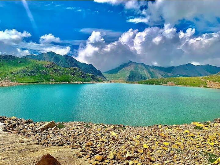
Like seven lakes, there are mythical stories woven around every other lake. The stories explain the genesis and power of each lake. The complex mountains that formed these lakes must have led to these stories. As always happens, everything complex and intricate must have an equally unusual and illogical explanation if not attended by scientific and informed view. The myth mongers and believers in superstitions sometime forget that a supernatural being is above cognitive faculty as well as the act of creation. Therefore, an object created and devoid of cognitive faculty even can not be supernatural.
A continuous chain of Lakes starts from Nandan Sar in the West to the Simar Sarin the East near Budhal. All the tourist spots including these lakes are above the height of 13000 ft from the sea level. As facilities like electricity, phone connectivity, railways and roads in the region are like a dream come true, therefore travelling on foot becomes mandatory to visit this area. From Pirki Gali walking towards the East, it takes almost 6-8 hrs to reach a very beautiful Nandan Sar lake, which lies in the lap of Nature between the two lofty peaks called Northern and Southern peaks of Nandan Sar. Nandan Sar is the largest, voluminous and the most famous among all other lakes of Pirpanjal range. This lake is almost one km long, oval with blue and fresh water and so far the most known to the travellers and visitors. Toward its north at a stride of 2 hrs comes the Katoria Sar, named after the bowl (Katori in local language). The Lake is very beautiful and remains laden with snow and icebergs till June-July. NandanSar and Katori Sar Lakes lie on either sides of a high mountain called Nandan Sarchot (peak). Another Chandan Sar (considerd Secred for Nomads), almost equal to the size of Nandan Sar lies just at half an hour stride from Nandan Sar. Towards East at a walking distance of one hour comes Kaldichni Sar, which is blackish in colour, horror in looks and oval in shape. In the same row towards North-East at a walking distance of one hour comes the famous Sukh Sar, which is another beautiful medium sized lake located in this region.
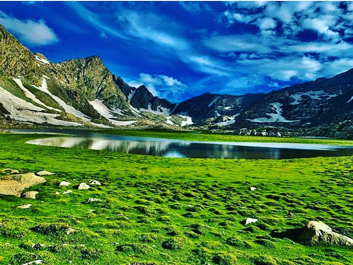
Towards the South-East of Sukh Sar, at a stride of half an hour in the lap of nature comes another beautiful and very attractive lake called Neel Sar. As its name indicates, it has crystal clear blue, clean and fresh water. The next destination after Neel Sar towards the North-East on foot for two hrs comes the Handu Sar, which is round in shape and comparatively smaller in size. Finally in this series of seven famous lakes the next one is Gum Sar, which is also a scenic beauty. It is an oval shaped lake near to Nandan Sar. One can reach Gum Sar by crossing the Nandan Pass towards the South of Nandan Sar. The nomads from Budhal, Bakori, Kalakote, Darhal and Thannamandi pass through these series of seven famous lakes to reach the Kashmir Valley during summer every year, in search of food and fodder for the cattle.
Another group of Lakes is Rawiwali Marg group of lakes located toward the West of Katoria Sar. This group consists of four famous lakes which are Kokar Sar, Neel Sar, Bhag Sar and Ding Sar, all above the altitude of 33000ft, could be the one of best camping sites for tourists. Other famous lakes of this 90kms long stretch are Jang Wali Sar and Kagalna Sar lakes towards the North-West at 2 hrs long walk from the famous Shakar Marg. Another very famous lake called SmatSar also known as Richh Bagla Sar, very much known for frequent visits of people and school children of Budhal and Bakori for excursions. It is just at a distance of 4-6 hrs stride towards the North of the Budhal town. It is almost one km long lake with fresh, clean and cold water. Other lakes mostly inaccessible, smaller in size and known to very few are Kala Sar, Chammar Sar (near Chammar Marg), a triangular Akhil Darshani Sar (near Sukh Sar), lamp shaped Diya Sar, and Padyaran Sar I & II (near Kalakote through Ropri pass).
The lush green meadows without presence of the high conifers and other woody trees,with fresh clean and cold air presents a heart throbbing view all around has become a great attraction for visitors. These meadows stretch from Budhal Dhoks (summer destinations for nomads) in the East to the Poonch Dhoks in the West. The famous Meadows (Margs) are Peer Marg near the famous Peer Ki Gali pass, near to it toward North is Doongi Marg. Then comes the famous Shakar Marg, the (Southern) most of all the meadows adjoining to the boundaries of Darhal of district Rajouri. Adjoining to this is Doodh Wali Marg, Khari Marg and Chammar Marg,all the three are towards North of Shakkar Marg almost at half an hour’s walking distance. Rupri Marg and Sheikh Marg adjoining to the Budhal area are also very beautiful meadows of Pir Panjal region. Jaddi Marg and Ravi Wali Margre two famous meadows under the jurisdiction of Poonch District. Other tourist spots worth visiting are Phanjari Marg, Goray Battay, Tegyar Choti (peak), Kgora, Namnad, Byadh, Khunali, Kagganali, Chapar Nalo, Kuthgal, Banj, Kundaan Dher, Kafarkatha, Gordiyan, Shaitani Paida, Girjan, Badjori Marg, Sari Mastaan, Marguri, Rupri Gali, Seti, Che Sari, Bela Marg and Sarota Marg(valley of flowers). All these places are either Dhoks for keeping cattle during summer, or the sites for summer camping and tours.
This segment of Pir Panchal range offers unusual spurs, spreading both South and north wards. First, the spurs sprout out at a distance of less than one km. Second the spurs lateral spreading on either side have smooth surfaces where snow accumulates in huge quantity, while as the main range is extremely rugged and badly broken that doesn’t permit snow accumulation. This led to much greater glacial activity on spurs than on the main range. With the result the area at some distance from main range gets blocked with material brought down by moving glaciers and the portion on the bottom of main range converted into a depression, that formed lakes. The formation of lakes like Neel and Sukh Sar and many tiny lakes in Sarota meadow, located considerably away from main range, may have been formed directly at the head of retreating glaciers, formed by uneven payload of terminal moraines, which signal the glacier has gone as far as it can go. Notwithstanding the myths and folk stories, one thing that even an ordinary student of geology can make out is that these lakes’ formation, at least the front ones, must be a very recent phenomenon. Rise of temperature during recent times has led to considerable retreat of glaciers from their erstwhile terminal points leaving behind depressions and uneven spread of moraine resulting in lake formations.
The beauty of the lakes, the majestic height of surrounding peaks, perennial glacier around, , lush green pastures a little downwards, murmuring birds on and around lakes, reverberating sounds of singing shepherds, absolute serenity, vast unpopulated swaths offering an opportunity for spiritual reflection, slow moving clean water, and the flocks of sheep make the scene an ultimate beauty that human eyes can hold. A visitor would always like to return here again and again. But non-availability of basic infrastructure like night staying facility and extreme weather make it difficult to stay there for a reasonably longer period. Unpredictability of weather and fast blowing night wind make tent pitching difficult near the lake area. One has to move a long distance downwards either side of the lakes area for night stay. The local dhoka structures area at a distance of more than three hours journey on Poonch side. They offer the only place for night stay. A tent can be pitched nearby dhoka structures only for reasons of safety from winds and wild animals.
Traditional routes that can be taken to reach these lakes.
PIR KE GALI TO NANDAN SAR*
One, Pir ki Gali to Nandan Sar route. This is the easiest route to reach lakes. It involves four hour walk. Nandan Sar is the first lake one reaches while taking this site. This route, on the whole, offers a plain walk. It’s, therefore, preferred by people who find it difficult to walk a steep rise. But there is a problem. A visitor can’t return seeing all seven lakes in a day. While getting back there is no reasonable place to stay put at night away from lakes until one gets back near Pir ki Gali. Therefore many people don’t prefer this route. People who take this route mostly return via other routes after a night or two stay in dhokas. Two, Baramgalla-Girjan-Bayarwali-lakes routes. This is the lengthiest but most beautiful of all routes. It involves the first 7 km steep rise from Baramgalla to Girjan Galli. Thereafter the other 8 km (approximately) is the most enjoyable plain walk through lush green Girjan dhok all along the bank of slow-moving musical Girjan River. One forgets the physical stress of steep rise reaching Girjan meadow. Towards the end of Girjan there is the other one and a half km patch of steep rise up till Bayar meadow. Ahead of Bayar meadow up till lakes is like a stair landscape of 7 km (approximately): a flat meadow followed by a gentle climb, again a flat meadow and a gentle climb, repeated four times. The first lake one reaches taking this route is SukhSar followed by Neel Sar. The visitors who have four or more days at their disposal must take this route. There are many dhok structures en route where one can pitch a tent alongside or stay inside a dhoka for the night. This route’s upwards trek takes not less than seven to ten hours depending upon the speed.
BARAMGALLA
Third, Baramgalla-Hassan Tham-Panjtari-lakes: This route involves first 6 kms (approximately) very gentle gradient up till Hasantham. From Hasantham to Panjtari Gali is a steep rise of 5km (approximately). Further onwards there is a plain walk of 4 km (approximately) through Panjtari meadow. Towards the end of Panjtari up till lakes the landscape is almost similar to that from Bayar meadow to lakes. This route involves not less than six to nine hour walk. While taking this route a visitor hits Gum Sar first followed by nandanSar, khaldachni, sukhSar, Neel Sar, Katori Sar and Katanan Sar.
DARHAL BUDHKHANARI
Darhal as a base point one can go through Budhkhanari. Thamal, Shakar Marg, Che Sari, Doodhwali Marg, Chammar, Handu pass, Bagh Sar, Sarota valley, Neel Sar, Girjan, to Noori Chamb, Behram Gala and back to Rajouri, which is one of the most appropriate and extensive area covering route for visitors. It involves a mixture of steep to gentle rise of 13km from Budhkhawari to Shakermarg or ladhimarg. From shakermarg or ladhimarg uptill Sarota Sar, a distance of 3km, is a walk full of enjoyment passing through meadows and fast running tributaries of Girjan river. From Sarota meadow the first lake that one hits is Katanan or Sarota Sar just 2km gentle rise from Sarota meadow followed by Katori, Neel, sukh, Kal dachni, Nandan Sar and Gum Sar. This route, if taken, offers an advantage of visiting other lakes like Jang Sar (Marriage lake), Kag alno (crows nest) and Handu Sar (Ram lake) provided one has an additional day at his disposal. These lakes fall on the right flank of Shakermarg-Sarota Sar portion of this route.
Having trekked on these routes, except a patch between Hasantham and Pajtari, I would suggest visitors to take Pir ki Gali route for the upward journey and return via any of the other three routes. This is the best to avoid steep upward trek that most people find difficult to take. This may not apply to those committing journey on horse. The best route for on horse journey is either via Panjtari or Girjan on account of spectacular natural settings enroute from beginning to end.
What makes a visit to these lakes difficult for most people is complete absence of any tourism infrastructure, from night staying facility to non availability of anything to eat en route. One is either on the mercy of people in meadows who are there to graze their cattle or will have to fetch eatables and night sleeping facility along. But fast blowing wind and presence of wild animals make it difficult to pitch tents anywhere. This compels a visitor to take local help compulsorily which may or may not come. Though a majority of flock rearing people in the meadow are extremely hospitable and warm but there are instances when some of them may not entertain. It’s therefore important that tourism department must make some arrangement, at least for night stay, preferably in the form of tent-accommodation at few places en route. Or, alternatively, the local private initiative may be encouraged with easy modes of permission to provide the basic facility at few defined places.
Author TAHIR MUSTAFA
MSC GEOGRAPHY
STUDENT OF ALIGARH MUSLIM UNIVERSITY



 Users Today : 44
 Users Yesterday : 166